It’s true: Divers discovered a mysterious island near Bulgaria on a map of several centuries
- By : Darkredowl
- Категория: Europe, News, Travel
It’s true: Divers a mysterious island near Bulgaria on a map of several centuries
During the current archeological season, in two stages – in the months of September and November 2023, a diving team led by the deputy director of the National History Museum of Bulgaria, Prof. Dr. Ivan Hristov, conducted underwater searches north of the mouth of the river. Kamchia. The studies are part of the project „Underwater archaeological research in the water area of the ancient Erite roadside station at the mouth of the Panysos River (Kamchia)“ with the financial support of the Ministry of Culture and the National History Museum.
The dive team’s first find is a lead ingot. A curious fact is that it reached the waters of the Black Sea from the Roman mines in the Cornwall area, according to the head of the research. There are parallels in ingots found in Roman Britain, and the object is dated to the 2nd-4th century. Historians point out that Cornwall and Devon only dominated the European tin market from late Roman times, beginning around the 3rd century AD, as many Spanish tin mines were exhausted.
Cornwall retained its importance as a source of tin throughout the Middle Ages and into the modern period.
This is the first find in Bulgarian territorial waters of such a nature and dating.
It weighs 5.35 kg and according to laboratory tests carried out at NIM, it contains 98% pure tin. Black Sea ingot was prepared for delivery to some workshop on land for making bronze objects or coins.
Another extremely rare object attracting the attention of archaeologists is a ritual vessel made of stone, called by the ancient Greeks a periranterium (περιρραντήριον). A periranterium (περι + ῥαίνειν) was an ancient Greek vessel used in pagan cults as a reservoir for holy water. It is made of cut stone, marble and less often of baked clay. It was found in various sanctuaries. The object is the first of its kind to come under water along our Black Sea coast.
It is also extremely rare on land.
Whether the stone object fell near the mouth of the Kamchia River from a sunken ship or was in place within the confines of a seaside sanctuary remains a mystery. But it is no accident that divers discovered half a stone stock deliberately cut as a gift to a shrine by traveling sailors.
During underwater research, whole and fragmented amphorae, as well as iron anchors from different historical periods, were found. An important find is the location of the remains of a sunken ship from the Ottoman period.
An excellently preserved wooden keel lies from it on the seabed. Divers recovered two cannons and fragments of pottery.
The ship sank probably in bad weather, seeking protection in the small bay of Cape Ilandjik. It is believed to have crashed on shallow sea reefs that are hard to see in a storm.
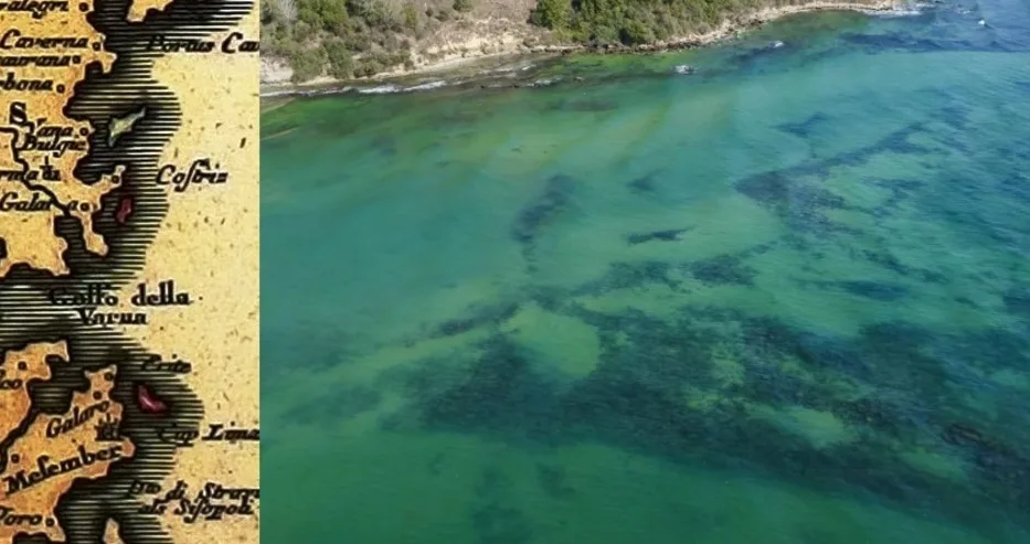
The project is related to conducting not only underwater searches, but also geophysical research between the mouth of the Kamchia River and Cape Paletsa, led by Eng. Kiril Velkovski, an associate of the Center for Underwater Archeology in Sozopol (CPA). Using a side-scanning sonar and a multibeam echo sounder, the borders of a seemingly disappeared mysterious island near the very mouth of the Kamchia River have been located.
From the data obtained, it can be concluded that the reef may have supported an island in the past, which most likely eroded.
This island was marked on numerous Western European maps in the period 1452-1750.
In a large part of the maps of this period, the images of islands that do not exist today or have smaller areas than those mapped then make an impression. Specialists from the Institute of Oceanology in the city of Varna share that a drop in sea level was observed during the Middle Ages.
This is the Korsun regression, named after the medieval city of Korsun (ancient Chersonesos, today’s Sevastopol in Ukraine).
Obviously during this period the coastline was different from today and it is quite expected that there would have been smaller or larger islands that were of importance to medieval navigators (places to shelter from strong winds, reef hazards, etc.). This is probably the case with the island in front of the mouth of Kamchia, called by the local fishermen the „Kamchia Stone“. The island is a reef with a slightly elongated shape in the north-south direction, with a width of approximately 520 m and a length of 870 m.
Scientific consultants for the research are Dr. Dragomir Garbov (Federal Ministry of Climate Change, Environment, Energy and Water Canberra, Australia) and Associate Professor Krum Bachvarov (University of Connecticut, Department of Anthropology). The team also includes: Todor Dimitrov – diver and photographer of the NIM, Eng. Totyo Angelov – cartographer and surveyor, Tencho Tenev – Manager of the Municipal Diving Center – Sozopol, Radostin Penev (CPA), professional divers and friends of the museum.
Specialists from the National History Museum point out that the water area between Cape Black and Cape Galata near the city of Varna is among the least explored underwater areas of the northern Bulgarian Black Sea. At the suggestion of the director of the CPA, Dr. Nayden Prahov, he began targeted research in this water area.